


HISTORIC TRIANGLE – The National Weather Service is warning Historic Triangle residents to prepare for several days of rain and strong winds beginning Tuesday, with tidal flooding expected to become a greater concern Wednesday and Thursday as a nor’easter develops off the coast. The agency says the coastal flooding warning will last through early Friday morning.
The National Weather Service put out a Coastal Hazard Message at 2:22 p.m. on Monday, Sept. 21. Affected areas include Charles City, New Kent, Gloucester, James City County, Newport News, York and Isle of Wight.
Flooding
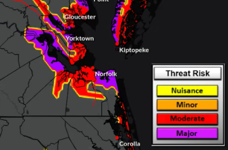
NWS said water levels will rise this week because of sustained northeasterly winds. According to their maps, the Historic Triangle can expect minor flooding on Tuesday, with potential moderate to major tidal flooding expected through Friday morning. Thursday is expected to have the highest amounts of potential tidal flooding.
The James River area at the Jamestown-Scotland Ferry and the Chesapeake Bay area near Yorktown could see minor flooding as soon as late Tuesday evening to early Wednesday morning, with moderate to major tidal flooding up to 5 feet expected by late Wednesday evening.
Coastal flood advisories remain in effect through early Wednesday, with minor flooding possible Tuesday. Water levels could rise up to 1 foot above ground level in low-lying areas, potentially causing road closures, particularly along the waterfront and shoreline. The National Weather Service urged residents to avoid driving on flooded roads.
The coastal flood watch will be in effect late Tuesday night through Friday morning, with the highest tides expected to occur Wednesday and again on Thursday. Flooding up to 2-3 feet above ground in areas subject to flooding is possible, likely leading to road closures. NWS warned that low-lying property may be at risk of coastal flooding.
Rainfall
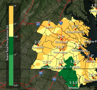
There is a slight risk of excessive rainfall for the Historic Triangle area on Tuesday. According to NWS’ Tuesday live briefing, rain is expected to become more widespread with some pockets of heavier rainfall that could lead to flash flooding.
Around 5 p.m. on Tuesday, there’s a low probability of up to three inches of rain for the Peninsula. However, excessive rainfall isn’t expected beyond Tuesday, with less than 1 inch of rain expected on Wednesday and minimal to no rain forecast on Thursday.
Wind
The NWS said the larger threats are the east-to-northeast wind gusts that will develop on Tuesday and persist through most of the week. They are expected to be 30-40 mph on the Peninsula, but the highest wind gusts are expected to occur along the coast on Wednesday and Thursday. Williamsburg is expected to receive wind gusts no greater than 29 mph on Wednesday and Thursday.
There will be more of a north wind on Friday, with winds expected to slowly decrease in the afternoon.
There is also a small craft advisory in effect through Tuesday evening due to northeast winds with gusts up to 35 knots and gale warnings in effect through Friday morning as possible gusts increase to 45 knots. The James River Bridge is included in the affected areas. NWS warns that strong winds can cause hazardous sea conditions that could capsize or damage vessels and reduce visibility.
Temperatures
Temperatures are expected to cool starting on Wednesday and stay between the mid-50s to mid-70s for the rest of the week.

