


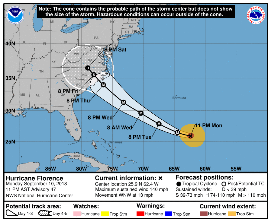
UPDATE 11 P.M. Monday
The latest update from the National Hurricane Center shows little change in Florence as the Category 4 storm continues to churn toward the East Coast.
At 11 p.m., Florence was about 1,085 miles east-southeast of Cape Fear, North Carolina. The storm was moving west-northwest at 13 mph, and its winds remained at 140 mph.
Storm surge and hurricane watches are likely to be posted Tuesday for portions of the area in Florence’s path, the hurricane center said.
The storm is expected to pick up speed and take a slight turn to the northwest over the next couple of days. It is expected to remain a major hurricane as it approaches the coast on Thursday, the hurricane center said.
UPDATE 6:30 p.m. Monday
Hurricane Florence remains a Category 4 storm with sustained winds near 140 mph, the National Hurricane Center said Monday evening.
Life-threatening storm surges are possible along the coasts of Virginia, North Carolina and South Carolina in the coming days as the storm approaches, the hurricane center said. A storm-surge watch is expected to be issued on Tuesday.
Florence is expected to slow down once it makes landfall and produce prolonged and especially heavy rainfall as it moves inland, according to the National Weather Service. While hurricane-force winds are expected in North Carolina and South Carolina, damaging winds are possible in Virginia as the storm moves inland.
The exact path of Florence remains unknown, but the storm is expected to make landfall Thursday near Wilmington. North Carolina, according to forecasters.
At 5 p.m. Monday, Florence was about 1,200 miles east-southeast of Cape Fear, North Carolina, the hurricane center said. The storm is moving west-northwest at 11 mph.
On Monday afternoon, Virginia Gov. Ralph Northam ordered mandatory evacuations from all Zone A areas beginning at 8 a.m. Tuesday.
In the Historic Triangle, the order affects much of Poquoson and Seaford in York County, and a handful of areas along the James River in James City County.
Original story:
Hurricane Florence has strengthened into a Category 4 storm as it continues to approach the East Coast, according to the latest updates from the National Weather Service.
The effect of the storm on Hampton Roads remains uncertain, however.
The latest storm models show Florence could come ashore near Wilmington, North Carolina, late Thursday or early Friday, while other models show the storm hitting farther up the North Carolina coast.
Florence is about 580 miles southeast of Bermuda and traveling west-northwest at 13 mph, the National Weather Service said Monday. The storm has sustained winds of 130 mph.
While Florence’s effect on the Historic Triangle and Hampton Roads remains uncertain, residents are being advised to prepare for drenching rains, strong storm surges and flooding.
Over the weekend, Gov. Ralph Northam issued a state of emergency in anticipation of the storm. The declaration allows the state to mobilize resources, including the Virginia National Guard, to assist in storm response and recovery efforts.
In Hampton Roads, Naval Station Norfolk is cautioning personnel against leaving their vehicles on base because of potential flooding. The base also is moving most of its ships out to sea to ride out the storm.
In North Carolina, officials in Dare County on the Outer Banks have ordered mandatory evacuations beginning at noon Monday.
Know your zone
While it is still to early to know if evacuations will be ordered on the Peninsula, the Virginia Department of Emergency Management is urging residents to “Know Your Zone.”
The program, which was rolled out last year, divides the region into four zones — labeled “A” through “D” — to help ensure orderly evacuations and avoid jamming roadways. Under the plan, those who live in “A” areas would remain be the first to evacuate while those in “D” areas would likely stay put.
You can find your zone by going to the “Know Your Zone” website.
Zone information is also available for those without internet access by calling 757-253-6612.
Be prepared
The federal government offers these guideline to build an emergency kit to help survive natural disasters:
Basic kit
To assemble your kit, store items in airtight plastic bags and put your entire disaster supplies kit in one or two easy-to-carry containers such as plastic bins or a duffel bag.
- 1 gallon of water per person per day for at least three days, for drinking and sanitation
- At least a three-day supply of non-perishable food
- Battery-powered or hand crank radio and a NOAA weather radio with tone alert
- Flashlight
- First aid kit
- Extra batteries
- Whistle to signal for help
- Dust mask to help filter contaminated air and plastic sheeting and duct tape to shelter-in-place
- Moist towelettes, garbage bags and plastic ties for personal sanitation
- Wrench or pliers to turn off utilities
- Manual can opener for food
- Local maps
- Cellphone with chargers and a backup battery
Additional Emergency Supplies
Consider adding the following items to your emergency supply kit based on your individual needs:
- Prescription medications
- Non-prescription medications such as pain relievers, anti-diarrhea medication, antacids or laxatives
- Glasses and contact lens solution
- Infant formula, bottles, diapers, wipes, diaper rash cream
- Pet food and extra water for your pet
- Cash or traveler’s checks
- Important family documents such as copies of insurance policies, identification and bank account records saved electronically or in a waterproof, portable container
- Sleeping bag or warm blanket for each person
- Complete change of clothing appropriate for your climate and sturdy shoes
- Household chlorine bleach and medicine dropper to disinfect water
- Fire extinguisher
- Matches in a waterproof container
- Feminine supplies and personal hygiene items
- Mess kits, paper cups, plates, paper towels and plastic utensils
- Paper and pencil
- Books, games, puzzles or other activities for children

