


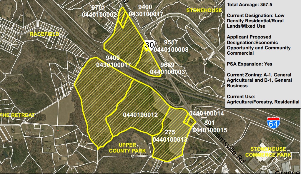
The owners of longtime farmland and some adjoining sites near Stonehouse have applied to position their land for future development.
The land has been in the Hazelwood family for generations and is composed of farmland and wooded areas. It is split by Interstate 64, with about 279 acres to the south of the highway and about 78 acres to the north.
The application seeks to identify the 279-acre tract as a site for future large-scale commercial or industrial development and the site to the north of the highway as a site for future commercial development.
The 279 acres to the south of the interstate stretches from Barhamsville Road and Old State Road west to Barnes Road, bordering the interstate to the north and Upper County Park to the south. The land to the north of the interstate is sandwiched between the interstate, Old Stage Road and some residential lands.
The application went before the James City County Planning Commission working group last week, which is considering it as part of the update to the county’s comprehensive plan. No decision was made about the application during the working group’s conversation about the application.
Attorney Tim Trant of Kaufman & Canoles spoke on behalf of the Hazelwood family at the commission’s meeting.
“They’re not interested in developing it or changing the character any time soon,” he said, noting development would only come when the “market will dictate it.”
He said analysis of the land shows it has potential for economic development because of its location at the intersection of Barhamsville Road and Interstate 64, which is accessible at the site via Exit 227. Environmental analysis of the land further shows it as a good site for development, he said.
The land is currently used for a few different purposes. Part of it is wooded, while another section is serving as farmland.
The land-use designation attached to a piece of land spells out its likely future uses. By shifting the designation of the land to the south of I-64 from a mix of rural lands and mixed use to economic opportunity, it would identify that land as a place for development that creates jobs and contributes to the county’s non-residential tax base.
The James City County Planning Division, which is tasked with analyzing the application, recommends the shift of the designation of the land south of I-64 to economic opportunity. In a memorandum to the working group, the land south of I-64 is identified as a prime site for one or more significant economic development projects as it is large, undeveloped, contiguous and owned by one party. The frontage along the interstate is also cited as a reason for supporting the shift.
The memorandum suggests language that limits retail construction on the land south of I-64. It also suggests residential not be allowed on the land. Trant said that while there is not anyone currently calling for residential construction on the property, completely removing it as a potential type of development “prematurely restricts” any vision for what could be built there.
The application outlines the land above I-64, which runs along Barhamsville Road, to be changed to the community commercial designation. That spells out moderate to large commercial development, which the application says could be used to support people living and working in the Stonehouse neighborhood and industrial park.
The planners suggest making all of the land north of the interstate mixed use, which allows for commercial, office and limited industrial development. That would keep the land more in character with the surrounding land in the Stonehouse development, which is already designated mixed use.
Along with changing the designation of the land, the request seeks to expand the Primary Service Area to encompass all of the property. One of the parcels of the land to the south of I-64 near Barnes Road is currently outside the PSA. The county uses the PSA as a tool for controlling growth: Land inside the PSA is eligible for higher density development along with county services like water and sewer.
A similar request to change the designation of longtime farmland near Anderson’s Corner to allow for future development is also being considered as part of the comprehensive plan update.
The designation change request is being considered as part of the comprehensive plan update. The planning commission working group will continue its analysis of the draft of the update into next year before handing the draft to the board of supervisors, which will review it during 2015.
