
For much of the year, visitors to Colonial Williamsburg received a map and list of activities detailing every building along Duke of Gloucester Street and beyond along with all activities going on for an entire week.
Printing that much information in one place required Colonial Williamsburg to fill a large sheet with a dense map of the living history museum on one side and small text arranged in long columns on the other, outlining each event, tour and restaurant available to guests across seven days.
“It was trying to be all things to all guests,” said Skip Ferebee, the director of consumer strategy and sales for Colonial Williamsburg. “If you’re a new guest looking at that for the first time, [you ask yourself] ‘Where do I begin?’”
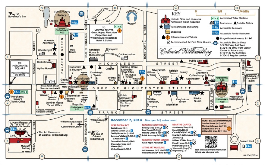
In the last few months, Colonial Williamsburg has done away with the bulky document and replaced it with a nimbler, daily printing that contains a map and list of activities specific to the day. The new document is far leaner, identifying landmarks throughout the living history museum on one side and specific activities — including recommended destinations for first-time visitors — on the other.
“We were forcing the guest to curate the experience [with the old map] and put too much energy into that,” Ferebee said.
To create the daily maps, Colonial Williamsburg researched other places with similar maps to determine what to show visitors. During that process, they decided to do away with showing each office and private residence in Colonial Williamsburg, instead focusing on historic buildings. Operating hours were also made more prominent.
He said Colonial Williamsburg is hearing the daily maps are a “home run” from guests who have used it. They were rolled out in time for the Grand Illumination on Dec. 7, allowing each event connected to the annual event to be highlighted and featured prominently on the list of activities rather than compete with all of the other activities of the week on the old map.
The change is the first from the newly formed Guest Experience Team, which seeks to find ways to make sure visitors to Colonial Williamsburg have the best possible visit. The team is one of several changes sparked by Colonial Williamsburg President and CEO Mitchell Reiss, who took the helm in October.
The team — made up of people from throughout Colonial Williamsburg — is wrestling with issues that include what the Colonial Williamsburg visitor’s journey is like from the time they leave home to the time they return, how easy it is to prepare for a trip to Colonial Williamsburg, how should visitors be welcomed by staff members and do visitors have the tools they need for a productive and fun visit.
When the team was first created, it went throughout Colonial Williamsburg and talked with employees at all levels, from historical interpretation to administration, to get a sense of what issues needed to be addressed to improve the experience of guests. That has so far yielded the daily maps. Future changes are currently being reviewed by Colonial Williamsburg.
The team is also exploring how to create a more customizable guest experience. Director of Historic Area Operations Diane Schwarz said Reiss is “big on customization” and the team is exploring how to use customization to better recommend specific activities for both new and returning guests.