
Hampton Roads has already experienced the worst of Hurricane Dorian’s rain and winds, meteorologists said late Friday morning.
“We’ve already seen the worst,” National Weather Service Wakefield meteorologist Mike Rusnak said. “The next couple hours, it will continue and then diminish later this afternoon.”
There is still a flash flood warning for parts of Hampton Roads, including Virginia Beach and parts of Chesapeake and Norfolk, Rusnak said around 11 a.m. Friday.
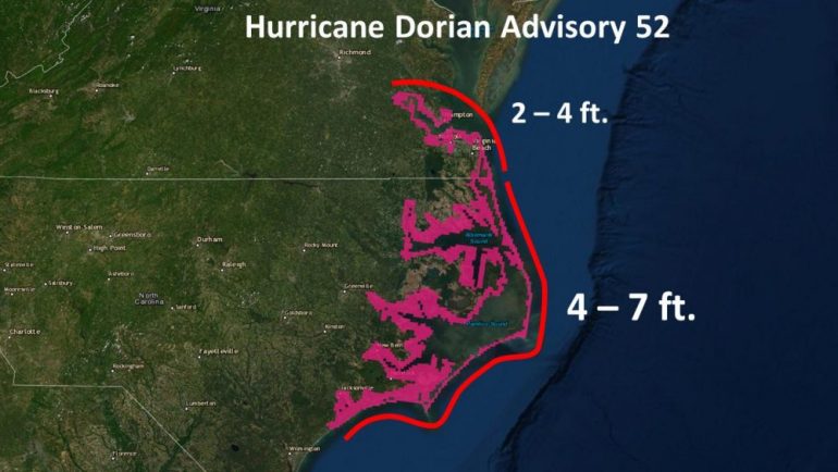
The National Hurricane Center said Friday morning a storm surge could cause water to reach at least 2 to 4 feet above ground in the area between Duck, North Carolina and Poquoson, including Hampton Roads.
Meanwhile, the sounds and the Neuse and Pamlico rivers in North Carolina could see 4- to 7-foot storm surges. Storm surges are an abnormal rise in water from a storm that is greater than the predicted tides.
Rusnak said bands of heavy rain — much like those experienced Friday morning — will continue to rotate in from the ocean until about 3:30 p.m. Friday.
Winds will be between 40 and 60 mph including gusts until mid-afternoon, which is about the same as they were Friday morning.
That weather won’t be any worse than what’s already been seen in the area.
The threat for tornadoes from Hurricane Dorian is also over, Rusnak said, adding it’s “just some rain for the next couple of hours.”
Saturday will be back to normal.
Weather in Hampton Roads is expected to be sunny with much less wind. Highs will be about 80 to 82 degrees.
“It’ll be normal summer weather tomorrow,” Rusnak said.