
HAMPTON ROADS— The National Weather Service is predicting colder temperatures this weekend, while the precipitation forecast of Winter Storm Fern is still fluctuating for the area.
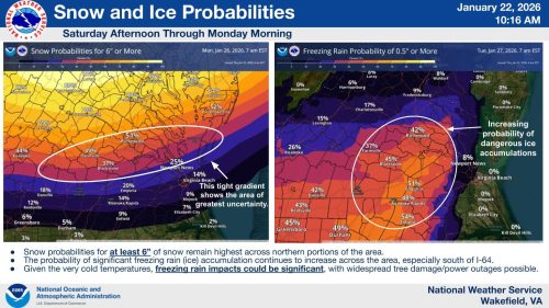
Local meteorologists have been tracking the incoming storm system since early this week, with chances and totals of snow, ice, and sleet changing almost daily. Current forecasts indicate that the Historic Triangle will see heavy mixed precipitation, including snow, sleet, and freezing rain. There is also potential for significant icing throughout the Hampton Roads region.
A winter storm watch has been issued by the National Weather Service and is in effect from Saturday afternoon through Monday morning. On Thursday afternoon, Gov. Abigail Spanberger declared a state of emergency ahead of the storm.
“Virginia is expecting a large winter storm that is predicted to impact the entire commonwealth,” Spanberger began. “I am asking all Virginians to stay off the roads as of Saturday night, all day Sunday, through Monday morning. This will allow not only for the safety and security of our neighbors, but it will allow for faster clearing of roads and ensure greater safety during what we expect will be the most dangerous times on the roads.”
Spanberger also announced that the Virginia National Guard will be mobilized during the storm for debris clearance and emergency response efforts.
Once precipitation from the storm stops, temperatures throughout the region are expected to drop into the mid to high 20s. With that, icing becomes a threat. Dominion Energy is advising customers that power outages could become widespread throughout the area.
“This has the potential to be a severe storm and multi-day power restoration effort. Heavy ice accumulation, severe damage to trees and power lines, and difficult travel conditions could prolong the power restoration effort over multiple days. Following the storm, we are expecting several days of extreme cold weather,” a spokesperson for Dominion said. “While the forecast could change, the greatest concern for power outages is ice accumulation greater than 0.25 inches in Central, Southside and southeastern Virginia, and northeastern North Carolina. This amount of ice can cause trees and large tree limbs to fall onto power lines, which is the leading cause of power outages.”
Dominion Energy also added that power restoration will be prioritized to hospitals, schools, water treatment facilities and other critical community services, as well as areas with the largest number of outages.
Spanberger and the Department of Emergency Management are urging Virginians to prepare now for the storm:
- Stay away from downed power lines. If you see a downed pole or wire, please report it by calling 866-DOM-HELP and stay at least 30 feet away. The line could be energized and dangerous.
- Fully charge devices before the storm. Fully charge phones, computers and other electronic devices before the storm arrives. Consider purchasing portable batteries to extend the life of your devices.
- Properly connect your generator. If you have a generator, make sure it is fueled, tested, and properly connected before the storm arrives, and always operate it outdoors with good ventilation.
- Prepare food, water and emergency supplies. Before any storm, it’s always good to have bottled water and non-perishable food on hand, as well as emergency supplies such as flashlights, batteries, first aid kits and medications.
For the latest weather updates, follow the National Weather Service, York County Office of Emergency Management, James City County Office of Emergency Management, and the City of Williamsburg Office of Emergency Management.