
 Williamsburg-James City County school board members are concerned local municipalities have not set aside enough land for new schools to accommodate for the projected population growth.
At the board’s Sept. 17 meeting, members decided to bring the City of Williamsburg and James City County into the discussion for finding a site for a fourth middle school. Board members wanted to know where future population growth is projected to help decide where to put the school.
Before the board right now is a decision on whether to build a new $40 million middle school and $8.5 million administrative building — both recommended by Superintendent Steven Constantino. The board has heavily discussed moving the administrative offices from James Blair Middle School to a new building that would require leveling James Blair for construction on the same site.
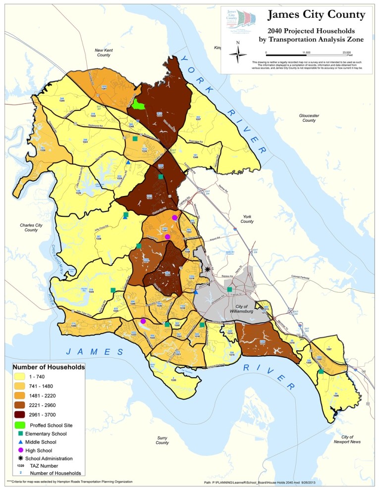
At Tuesday’s school board meeting, Leanne Reidenbach, a senior county planner, showed the best picture the county has for where the population will grow. Two maps comprised the information: a transportation planning map and a buildout map.
The buildout map shows the percentage of houses that have already been built out of how many are allowed by the county in recognizable sections of the county, like New Town or Stonehouse. Reidenbach said areas shown to have much available space could be an indicator of where future growth will happen: the more available space there is, the more potential for future population growth.
The other map shows tracts of land — defined by the Hampton Roads Transportation Planning Organization — that are projected to need upgrades to their transportation infrastructure by 2040. On the map, the number of households projected for 2040 is also included in each tract of land. Reidenbach said it could be another indicator of where populations will be in the future.
Reading the maps
Both the transportation and buildout maps indicate the Stonehouse area — that already has a proffered school site — could possibly see heavy future population growth.
A few other areas in the county show a potential for a large amount of households in the future. For example, a large chunk of the Colonial Heritage neighborhood and a few off Longhill Road like Ford’s Colony and Windsor Forest.
Two areas without names were also identified as upcoming areas of high population:
- An area just south of Croaker Road and Interstate 64 that was identified, according to Reidenbach, as an “economic opportunity area.”
- An area just south of the intersection of Richmond Road and Croaker Road that Reidenbach called the “Candle Factory development.”
At the end of the presentation, there were no suggestions from the board for a future school site. Instead, there was a call from Chairwoman Ruth Larson and Superintendent Steven Constantino to enter a more in-depth conversation about future schools with the county.
Imperfect system
Available maps are an imperfect system for predicting where schools should be placed in the county, Reidenbach said, as the maps do not account for things like age demographic or how many children will be present in each area. Also, she said, just because an area shows a low buildout, doesn’t mean that future populations will move into the area.
“There are so many unknown variables,” she said.
The county has in its plans one future school site in the Stonehouse area set aside when developer GS Stonehouse Green Land Sub, LLC bought the land in 2007. Other than that, there are no other planned school sites in the county’s plan – and that seemed to concern school board members.
“We may want to start looking at that so that we’re prepared when that moment arrives,” said Board Member James Nickols. “Because with a lot of growth comes a lot of usage of land. And then when the land needs to be had, it’s not there to be had.”
For school board members, another problem with available data for school board members is there is no household count for 2013 to compare to the projected 2040 numbers. The best available data is from the 2010 U.S. Census.
“I might just be a lot more literal, but it’s really hard for me to not have that information and be able to compare,” Board Member Heather Cordasco said.
A people divided by mismatching borders
While the county does have 2010 census data as the next best thing to compare to 2040 projected county household counts, there are still problems with using the data to predict where future populations may be. It has to do with different-sized spatial units — units on a map like states, counties or countries — that create something Reidenbach called an “unequal comparison.”
Imagine looking at a map of every county in the state that has a population count penciled into each county. Predicting the population for the entire state would be as easy as summing all county populations. But if a few of the counties, instead, reached into another state — partly in Virginia and partly in North Carolina — it would be difficult to accurately sum the population of Virginia from that data.
That, in essence, is the problem with the 2010 census data: it’s collected within census tracts while the available data is divided into neighborhoods and those borders created by HRTPO. Because the spatial units were created for different reasons, their borders don’t match so accurately saying how many households now reside within those HRTPO borders is problematic.
Development in the city
Right now, in the City of Williamsburg’s 9 square miles, three school sites are identified: Matthew Whaley Elementary, Berkeley Middle and James Blair Middle, which now houses administration. City Planning Director Reed Nester said there is also about 3 acres of a city-owned lot south of Berkeley Middle School that was approved for a school building in 2005 but was never built.
Nester painted a detailed picture to the school board about where future growth and development in the city would most likely occur. The answer was mostly —about 73 percent of the estimated growth — in mixed-use areas, such as the Quarterpath at Williamsburg and the developing High Street community off Richmond Road.
“The City of Williamsburg being a small community of only nine square miles, it makes it a little easier to get a handle on development,” Nester said.