
Centuries ago they were used to guide weary travelers or document new discoveries — the antique maps of Virginia, which tell tales of past adventure, exploration and conquest.
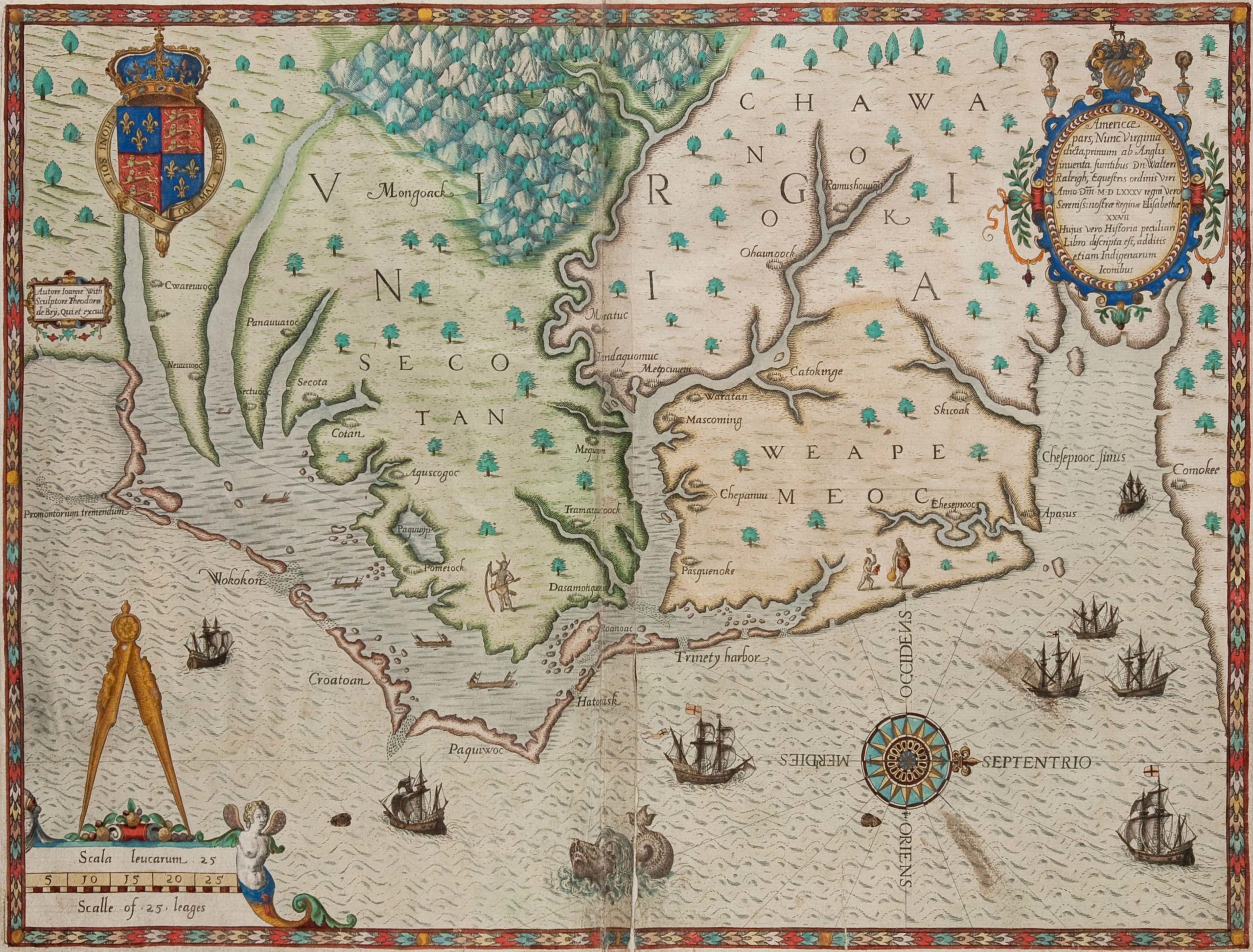
Some have engravings portraying the Commonwealth as a latter-day Eden. Others contain the first printed record of Sir Walter Raleigh’s attempts to plant a colony in the New World.
Others still show military strategy at Yorktown and Gloucester Point.
All told, these antique maps with a glimpse into our rich history are available today for everyone to view.
The Colonial Williamsburg Foundation has acquired the Wooldridge Collection — a trove of more than 220 maps, charts and atlases depicting the early days of Virginia life between 1540 and 1835.
This spring, the collection will be available digitally through the Foundation’s online database.
Ultimately, the maps will be on display in multiple future exhibitions at the Art Museums of Colonial Williamsburg. The maps have been acquired in part through a gift and purchase agreement, according to a press release.
“Maps are among the most illuminating of artifacts because they reveal the interests, aspirations and even biases of those who made and used them,” said Ronald Hurst, Colonial Williamsburg’s Carlisle Humelsine chief curator.
“When paired with the Foundation’s early Virginia maps, the Wooldridge Collection gives us an unparalleled ability to understand and share Virginia’s role in our national story,” Hurst added.
William C. Wooldridge of Suffolk amassed the collection over the past four decades. They were recently owned by the Virginia Cartographical Society, a private, Norfolk, Virginia-based consortium.
Curators at Colonial Williamsburg say it is the most comprehensive collection of Virginia maps outside of the Library of Congress.
According to a press release from Colonial Williamsburg, highlights from the collection include a visually unique map — ‘Carta particolare dela Virginia Vecchia e Nuova’ by Sir Robert Dudley, published in Florence, Italy, 1647 — which was made to help facilitate travel.
One map depicts a scene from the Native American “Town of Secota,” and shows an abundance of thriving crops in neatly ordered gardens carefully manicured by a native population.
Another map shows one of the final battles in the American Revolution in 1781. In typical fashion, immediately after the British surrender at Yorktown, generals had engineers create surveys of the battlefield.
One such survey, the ‘Plan of the Investment of York and Gloucester,’ was produced by George Washington’s engineer, Major Sebastian Bauman. He served as artillery commander at West Point in 1779 after emigrating from Austria.
One section on the map’s top half shows Yorktown, Gloucester Point and various troop positions.
The bottom half, amid flags, banners and other ornaments of war, is an open space in the very heart of the map, with the words:
“The Field where the British laid down their Arms.”