
HISTORIC TRIANGLE— The Historic Triangle, and much of the Commonwealth, are bracing for tornadoes, thunderstorms and high winds throughout the day as a cold front is expected to bring severe weather to the region.
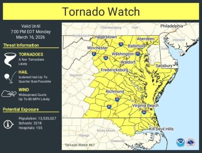
According to a Hazardous Weather Outlook from the National Weather Service, a strong cold front will cross the region today into this evening, bringing a significant risk for severe thunderstorms. In addition to the thunderstorms, there is potential for damaging winds and tornadoes before the front arrives this morning and after the front arrives this afternoon.
A gale warning is in effect for the Chesapeake Bay, Atlantic coastal waters, the lower James River and the Currituck Sound.
Customers who ride the Jamestown-Scotland Ferry have been advised to expect potential service interruptions between approximately 2 p.m. and midnight due to the severe storm conditions forecast. Motorists should plan for potential delays and are encouraged to call the ferry hotline at 800-VA-FERRY (800-823-3779) and visit the 511 Virginia website for the latest reported status updates on ferry service to determine if an alternate route is needed.
The tornado watch for the area remains in effect until 7 p.m.
Watch vs. Warning?
Watches and warnings are often created when hazardous conditions are predicted. However, watches and warnings are often confused with one another, so what do they mean?
According to Weather.gov, a watch is used when the risk of a hazardous weather or hydrologic event has increased significantly, but its occurrence, location or timing is still uncertain. It is intended to provide enough lead time so those who need to set their plans in motion can do so.
When a warning is issued, a hazardous weather or hydrologic event is occurring, imminent or likely. A warning means weather conditions pose a threat to life or property. People in the path of the storm need to take protective action.
For the latest weather updates, follow the National Weather Service, York County Office of Emergency Management, James City County Office of Emergency Management, and the City of Williamsburg Office of Emergency Management.